 Overview on portable activities and locations

- Current equipment
My current equipment for 2m and 70cm - SSB portable operations:
Antenna:               2m: 6 ele yagi, DK7ZB 28-Ohm design
                       70cm: 9 ele yagi, DK7ZB 28-Ohm design
                       mounted at 3m or 6m Al pluggable rod
Antenna rotor:         model "armstrong"
Station:               ICOM IC-706MkIIG (2-50W/15W) or FT-817ND (5W)
Cables and connectors: EcoFlex 10 or AirCell 7 + N-connectors
Power Amplifier:       ---
Power supply:          36Ah car battery
More:                  SWR-Meter + Digital Multimeter
Usually I have also a 2m FM Handy with me to do local QSOs or repeater QSOs. - JN49GC - Michaelsberg

This is a small, flat 'hill' very close to the village Bruchsal-Untergrombach. Its height is approx. 269 m asl and there is a small chapel and a well known restaurant close to the top. One can directly drive on the hill and park the car near the vincinity of the peak.
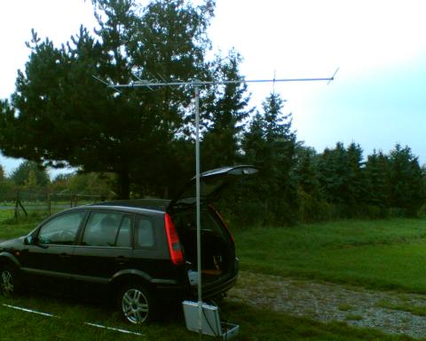
The image below shows a typical setup (well I had forgotten some stuff to use the complete 6m rod that time) on the Michaelsberg, here end of August 2008 in the Saar-Kontest.

Get the JN49GC.kml file to view the location with GoogleEarth (if installed) or follow this link to view it with GoogleMaps.
- JN49BH - Hambacher Schloss
This QTH is in the vincinity of the historical place 'Hambacher Schloss' near the city Neustadt/Weinstrasse in Rhinland Palatine. There are a large parking place and more parking opportunities behind this castle, but the takeoff is not the best from there.
Thus it is more convenient (allthough one has to climb up approx. 180 m) to climb up the hill behind that location with a height of 527 m asl, the takeoff is excellent into east direction - one could point the antenne from JO33 until JN37, so more than 180 degree field of view. To the west some pine trees, the smooth rising altitude of the hilltop and some higher peaks (above 600 m) hinder QSOs in that direction.Get the JN49BH.kml file to view the location with GoogleEarth (if installed) or follow this link to view it with GoogleMaps.
- References
- GoogleMaps
- GoogleEarth
- Displaying maps with GoogleMaps with locator info, try '?locator=FF54' for instance
- Displaying a locator field with GoogleEarth (my source for the kml-files)